

Pavement Ends
James Baughn was the webmaster of seMissourian.com and its sister newspapers for 20 years. On the side, he maintained even more sites, including Bridgehunter.com, LandmarkHunter.com, TheCapeRock.com, and Humorix. Baughn passed away in 2020 while doing one of the things he loved most: hiking in Southeast Missouri. Here is an archive of his writing about hiking and nature in our area.
- Email link
- Read comments (5)
- Share:


Falling Spring: The name says it all
Posted Tuesday, August 12, 2008, at 12:29 PM
What happens when you combine a spring and a waterfall? You get this:

Deep within the Mark Twain National Forest in Oregon County, the water at Falling Spring gushes from the side of a bluff and drops 8-10 feet into a pond.
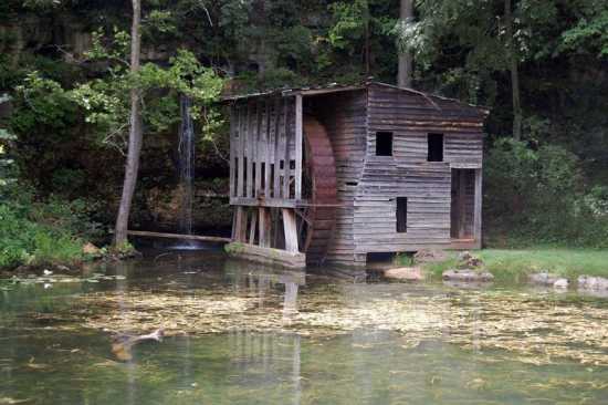
By itself, the falls would make for a spectacular sight. But Falling Spring also includes a preserved mill:
And a log cabin:

Falling Spring was homesteaded in 1851 by the Thomas Brown family. They moved from Tennessee, crossing the Mississippi River at "Green's Old Ferry" (present-day Trails of Tears State Park) and continued westward into Oregon County. It's no surprise that they would have chosen this site for their new home. The Brown cabin, with its half-dovetailed log joints, has stood the test of time and remains in good condition, except for some graffiti.

The spring, with an average production of 500,000 gallons per day, was the perfect place for a homestead and mill. The current mill, built in the late 1920s, still has an overshot wheel and some of the interior machinery:


The mill sits immediately next to the spring. Originally, a chute would have connected the spring outlet with the overshot wheel.

Water from the spring fills an artificial mill pond:

In its heyday, the Falling Spring settlement was an important waypoint on the "Old Thomasville Road" pioneer road leading from Carter to Oregon counties. Today, this is a remote, and largely undiscovered, recreation area served by a narrow National Forest lane that carries very little traffic.
Located 150 miles from Cape Girardeau, Falling Spring wouldn't be worth the drive by itself. This corner of the Ozarks, however, features plenty to see and do... but I'll save that for the next blog.
Driving directions
1. Take your favorite route to Van Buren. The fastest route is I-55 south to Sikeston and then west on US 60, but Highway 34 through Marble Hill and Piedmont is more scenic.
2. Follow US 60 west from Van Buren and make a left on Highway 19 South at Winona.
3. Take Highway 19 for ten miles, enjoying the G-forces of the roller-coaster up and down hills along the road, and then keep your eyes peeled for the Falling Spring turnoff (on the left) at Forest Road 3170.
4. Bear left at the fork in the road and take Forest Road 3164 (also marked as County Road 156). Just short of two miles down this road, watch out for the ridiculously sharp turns as the road snakes past the Falling Spring cemetery. The parking area is just ahead on the right.
Quick facts
Name: Falling Spring
What: Spring and waterfall, plus old homestead with preserved mill and log cabin
Where: Oregon County, south of Winona
Owner: Mark Twain National Forest (purchased in 1966)
GPS coordinates: 36.8676, -91.2950
Topographic map: Greer
- Email link
- Read comments (5)
- Share:
Trip Planner

Respond to this blog
Posting a comment requires a subscription.