NewsAugust 3, 2019
The Flood of 2019 — by the (really big) numbers
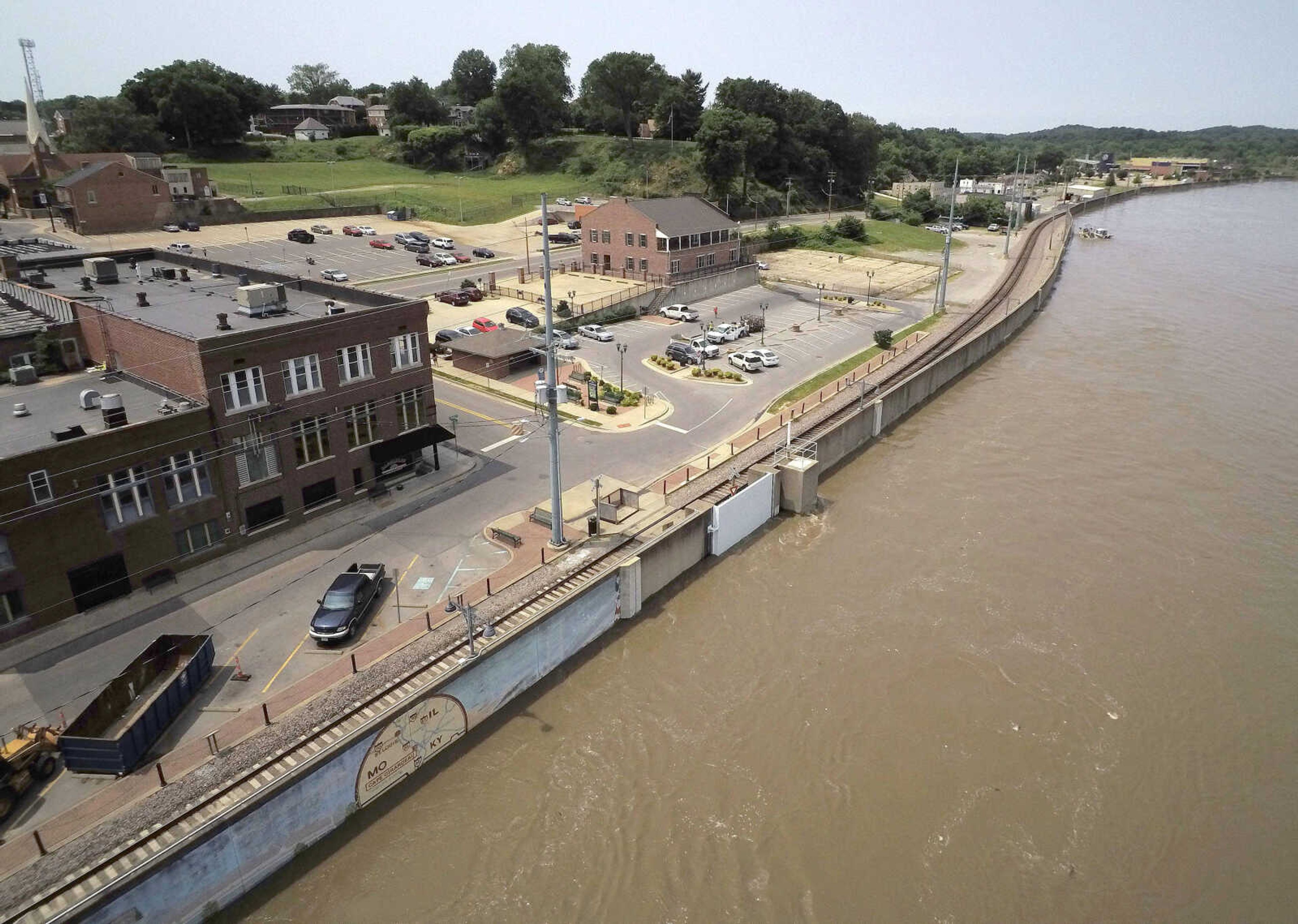
The Mississippi River’s record-breaking flood of 2019 will officially end this weekend as the river falls below flood stage at Cape Girardeau for the first time since mid-March.
According to the National Weather Service in Paducah, Kentucky, the reading on the Cape Girardeau gauge will dip below 32 feet late Saturday night or early Sunday morning, ending a streak of 144 consecutive days of flooding beginning March 15, nearly three weeks longer than the old record of 125 consecutive days above flood stage set between June 10 and Oct. 12, 1993. ...
The Mississippi River’s record-breaking flood of 2019 will officially end this weekend as the river falls below flood stage at Cape Girardeau for the first time since mid-March.
According to the National Weather Service in Paducah, Kentucky, the reading on the Cape Girardeau gauge will dip below 32 feet late Saturday night or early Sunday morning, ending a streak of 144 consecutive days of flooding beginning March 15, nearly three weeks longer than the old record of 125 consecutive days above flood stage set between June 10 and Oct. 12, 1993.
The river at Cape Girardeau crested June 12 at 46.29 feet, more than 14 feet above flood stage but about 2.5 feet below the record crest of 48.86 feet set Jan. 2, 2016.
Receive Daily Headlines FREESign up today!
This year’s crest was the fifth-highest recorded at the Cape Girardeau riverfront, according to the U.S. Army Corps of Engineers, which has tracked river crest data since the 1800s. Cape Girardeau’s second-highest crest was 48.5 feet Aug. 8, 1993, while the third highest was 47 feet May 24, 1995, and ranking fourth was a crest of 46.9 feet Aug. 3, 1993.
Here are a few statistics related to the “Flood of 2019” and its impact on the area:
- The Broadway floodgate in downtown Cape Girardeau was closed 130 consecutive days, from March 15 until July 22, while the gate at the foot of Themis Street was closed 139 consecutive days, from March 14 until July 30, marking the longest closure since the floodwall was completed in 1964.
- According to Cape Girardeau sewer and stormwater supervisor Gary Middleton, Cape Girardeau pumping stations have been staffed 24 hours a day and running nonstop since mid-March. By the time the pumps are finally switched off this weekend, Middleton said they will have been running 145 straight days.
- The Mississippi River Bridge at Chester, Illinois, was closed for 20 days, from June 2 to 22, when the river there rose above 40 feet. According to the Missouri Department of Transportation, that was one of the longest closures of the bridge since it opened in 1946.
- Flooding within the water-saturated levee system of Southern Illinois forced the Illinois Department of Transportation to close Illinois Route 3 near Cora, Illinois, in northern Union County from May 2 until July 9, 68 consecutive days.
- Seep water in Alexander County, Illinois, resulted in the closure of routes 3 and 146 between East Cape Girardeau and McClure for 36 days, from June 21 until July 26. Several miles of Route 3, from Route 146 south to Gale, Illinois, were closed even longer, 45 days, from June 15 until July 29.
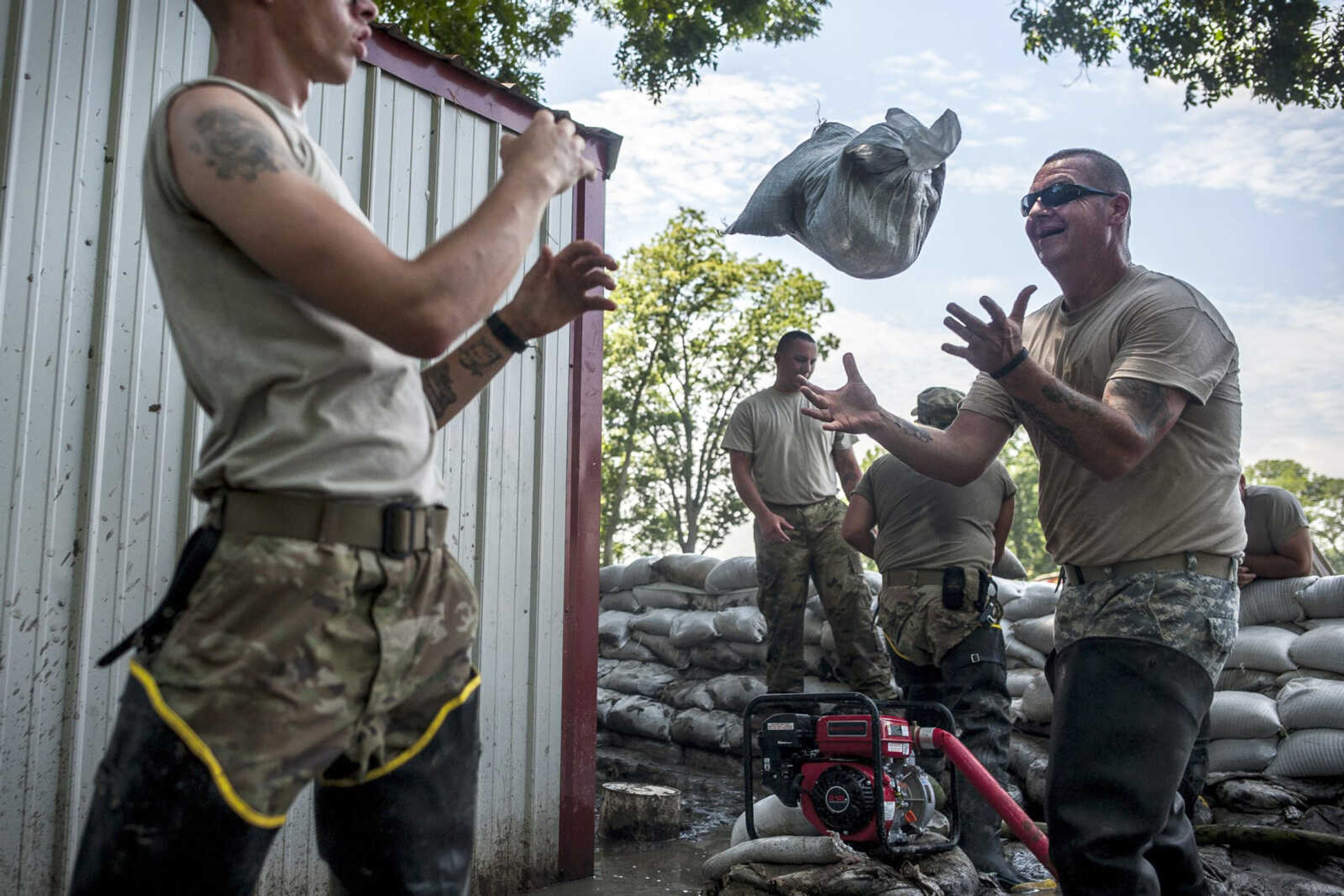
- “Well over 250,000 sandbags” were used in Alexander County in the East Cape Girardeau and McClure areas, according to Chris Pulley, coordinator of the Illinois Emergency Management Agency’s Region 11 in Marion. At an average weight of 40 pounds each, that’s 10 million pounds of sandbags, or 5,000 tons (that’s “dry” weight; wet sandbags weigh substantially more).
- As of Aug. 1, nearly 26,000 acres of farmland in Alexander County have been listed as unplantable because of flooding, according to the U.S. Department of Agriculture Farm Service Agency office in Anna, Illinois. Based on average yields per acre of the corn, soybeans and rice that would have been planted on those acres and the fall delivery market prices for those crops, Alexander County emergency management director Mike Turner estimated flood-related crop loses in the county at just under $14 million. “That is revenue lost based on the number of acres that were not able to be planted due to flooding,” Turner said. He noted estimates for structural damages caused by the flood are still being calculated.
- Turner said there hasn’t been a day since Dec. 28 — when the Ohio River at Cairo, Illinois, surpassed flood stage — pumps haven’t been running somewhere in Alexander County, with as many as 25 pumps running simultaneously. “This is, by far, a record number of days for nonstop pumping,” he said. “And that’s not counting the pump stations or the small 2- and 3-inch pumps, just the large diesel fuel pumps.”
- In addition to flooding caused by seep water through and under the Alexander County levee system, much of the flooding in the county has been the result of excessive rainfall. According to the National Weather Service, 40 inches of rain fell on Alexander County during the first six months of 2019, almost double the amount of precipitation the county receives in a typical year.
- One inch of rain is the equivalent of 27,000 gallons of water per acre. The floodgates at Gale drain water from approximately 57,000 acres in Alexander and Union counties, meaning 40 inches of rain was the equivalent of more than 61.5 billion gallons of water on those 57,000 acres between Jan. 1 and June 30. “And that’s not counting July, which was wetter than usual also,” Turner said.
Do you crave business news? Check out B Magazine, and the B Magazine email newsletter. Check it out at www.semissourian.com/newsletters to find out more.
Story Tags
Advertisement
Connect with the Southeast Missourian Newsroom:
For corrections to this story or other insights for the editor, click here. To submit a letter to the editor, click here. To learn about the Southeast Missourian’s AI Policy, click here.


Advertisement
Receive Daily Headlines FREESign up today!
