NewsApril 13, 2008
Cape sinkhole total reaches 20 as five more appear
With the discovery of sinkholes 16 through 20 since March 19, Cape Girardeau officials are hoping for more federal help. Results of a joint study by the U.S. Army Corps of Engineers, the city and Missouri Department of Natural Resources geologists will be released May 31. The $50,000 study will explain what's causing the sinkholes and suggest how to prevent future ones and keep filled holes from reopening. The corps and the city split the cost of the study...
With the discovery of sinkholes 16 through 20 since March 19, Cape Girardeau officials are hoping for more federal help.
Results of a joint study by the U.S. Army Corps of Engineers, the city and Missouri Department of Natural Resources geologists will be released May 31. The $50,000 study will explain what's causing the sinkholes and suggest how to prevent future ones and keep filled holes from reopening. The corps and the city split the cost of the study.
On March 28 the city sent an appeal to the corps for a $100,000 federally funded emergency stream-bank protection study. Several of the sinkholes, including No. 19, have developed along the banks of Cape LaCroix Creek. In other areas, the banks have begun falling into the creek.
If the Corps of Engineers agrees to that study, it may result in a joint repair project. The corps would pay 65 percent of the cost; the city would pay the remaining costs to stabilize the creek banks.
FEMA officials, in Southeast Missouri dealing with flood and ice storm disasters, have been informally approached by city officials, who asked about funding. If the city makes a formal request, it would have to go through the state first.
"We have apprised the state emergency management agency and our local politicians, state and federal, and everyone is trying to do something; however, there doesn't appear to be any direct funding mechanism at this time," said Mark Hasheider, the city's assistant fire chief and emergency operations director.
FEMA did help the city of Richmond, Va., replace a sinkhole-threatened sewer line after the hole was determined to be caused by a 2006 hurricane.
Cape Girardeau's sinkholes have been developing at an increasing rate, just west and south of the city's wastewater treatment plant. The holes appear to be limited to 100 acres in that area, a relatively small chunk of the city.
"Cape is not going to be swallowed up by a bunch of sinkholes," said Ken Eftink, director of development services for the city.
Annie Anand, the city's geographic information systems coordinator, has spent hundreds of hours documenting and mapping the holes, producing aerial photos marked with numbered yellow dots, indicating when and where the holes developed. No. 20, which is about 20 feet wide and 20 feet deep, appeared last week along the edge of the filled and capped No. 14.
Her work is the basis for the 28-page report used to request the emergency stream-bank protection study, which was signed by her boss, Eftink.
"The problems we are experiencing include stream-bank failure and bed degradation in an area where sinkhole activity has been dramatic, with 18 sinkholes forming rapidly in the past nine months," the report stated. "The city's only wastewater treatment plant is threatened by both the sinkholes in the immediate area and the bank failures," the report stated, adding in a later passage that there "is a threat of a shutdown to a nearby quarry and a cement processing operation because of creek water flowing directly into the quarry from the sinkholes that suddenly collapse within the creek."
Receive Daily Headlines FREESign up today!
The sinkholes have appeared on city property and land owned by Buzzi Unicem, SEMO Stone Co., Burlington Northern Santa Fe Railroad, Southeast Missouri Port Authority and AmerenUE. The utility company had to move a major gas line supplying the city in two locations as well a relocate an overhead electric line. The railroads have repaired tracks; Burlington Northern installed a series of sensors that issue alerts if the ground shifts near or under tracks.
U.S. Rep. Jo Ann Emerson toured the site last year and again April 4; U.S. Sens. Kit Bond and Claire McCaskill and state Sen. Jason Crowell made site visits in March.
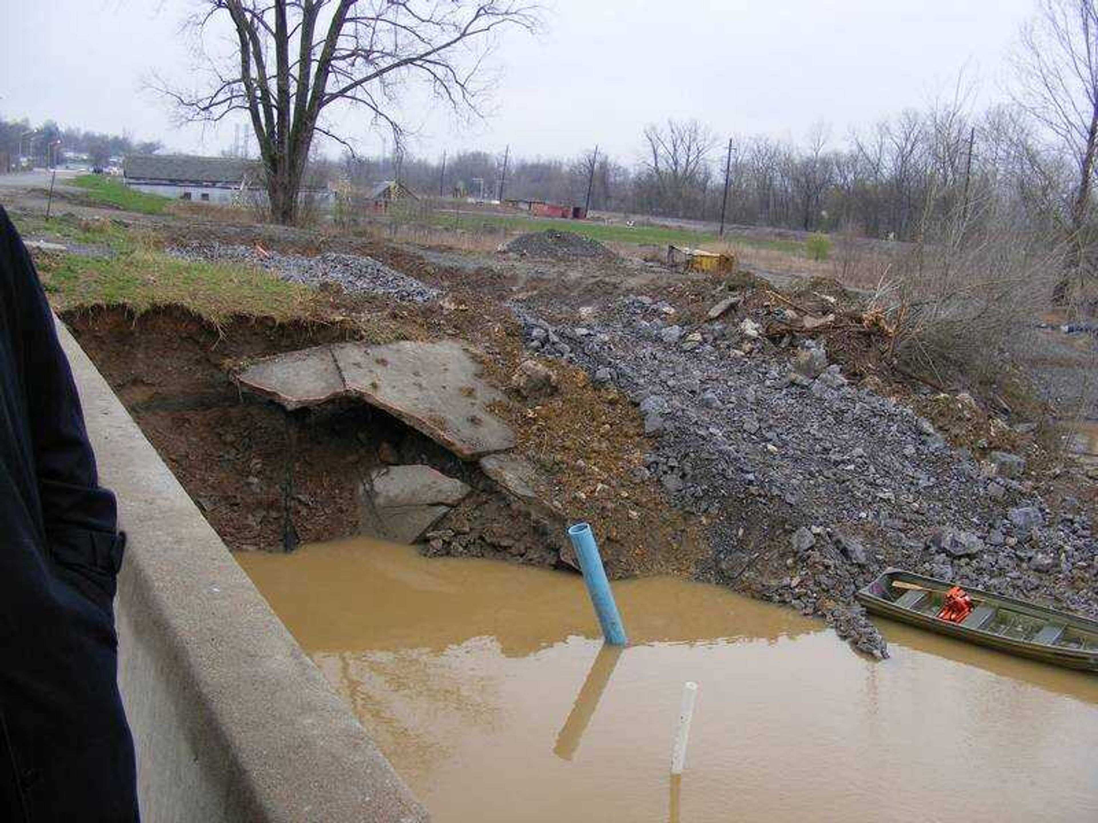
Eftink told Emerson the holes appear to be related. As they stood on the South Sprigg Street bridge, he pointed out No. 19, on the Cape LaCroix Creek bank just northeast of the bridge, and Nos. 15 and 1, on the bank southeast of the bridge.
As he spoke, work crews were near the older holes, filling them with cement, over which rocks would eventually be piled, forming a mound. Eftink said the filling and sealing process is intended to pressurize the underground space and keep water from seeping back through. Workers on the site said they'd spent three days pouring cement into an older hole that had reopened.
Sinkholes form after underground water moves through layers of ground, creating holes big enough that the surface soil collapses. The land around and under Cape LaCroix Creek is primarily a type of limestone that quickly dissolves. The force of the water carries the dissolved limestone, small rocks and dirt to the nearest opening. The water travels to the quarry operated by Buzzi Unicem, a cement manufacturer and one of the city's largest employers and taxpayers.
Underground water will fill any low spots it encounters, in this case the Buzzi Unicem quarry, which is an estimated 300 feet deep. The farther water falls, the faster it travels and the quicker underground layers are scoured. The limestone-rich water splashes through openings on the quarry's northeast wall, falling into a 100-foot-deep murky and growing lake below.
Until the Corps of Engineers report is delivered, each property owner is making its own repairs and paying its own costs. The city has spent more than $40,000, Eftink said.
"We expect more, as the river waters rise and recede," he said. "We've been seeing one show up every week or so and don't anticipate that changing anytime soon."
pmcnichol@semissourian.com
335-6611, extension 127
Does this affect you?
Have a comment?
Log on to semissourian.com/today
Story Tags
Connect with the Southeast Missourian Newsroom:
For corrections to this story or other insights for the editor, click here. To submit a letter to the editor, click here. To learn about the Southeast Missourian’s AI Policy, click here.
Related


Advertisement
Receive Daily Headlines FREESign up today!
