NewsApril 1, 2011
St. Louis would lose congressional seat in initial redistricting plan
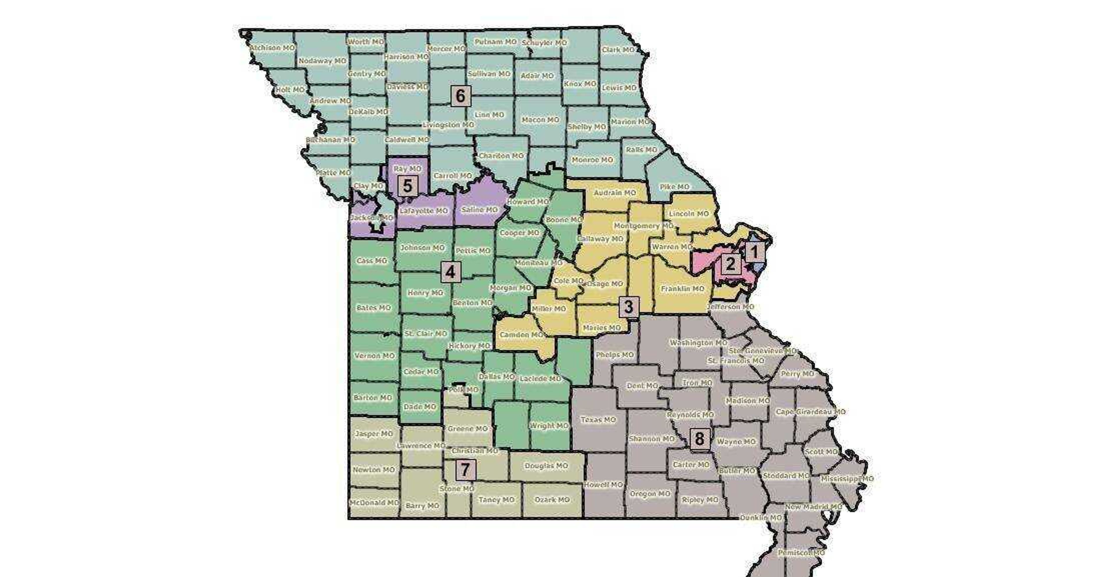
St. Louis would lose one of its two members of Congress and much of northern Missouri would be covered by a single congressional district under a redistricting proposal released Wednesday by a state House committee.
From staff and wire reports
St. Louis would lose one of its two members of Congress and much of northern Missouri would be covered by a single congressional district under a redistricting proposal released Wednesday by a state House committee.
The new congressional map also would reshape the Kansas City-area district held by Democrat Emanuel Cleaver to add part of Clay County and a couple of largely rural counties east of the state's largest city. Cleaver's district is a traditional Democratic stronghold.
Missouri lawmakers this year are responsible for drawing a new congressional map that has eight congressional districts instead of nine because the state's 7 percent population growth over the past decade did not keep pace with the nation. State lawmakers have said every congressional district was likely to change.
The map unveiled Wednesday calls for the northwestern Missouri congressional district held by Republican Sam Graves to be spread across the state from the border with Kansas and Nebraska to the Mississippi River and cover much of relatively sparsely populated northern Missouri.
Much of the attention, however, has focused on the St. Louis area, the Democrats' other stronghold in Missouri. Democratic Reps. Lacy Clay and Russ Carnahan both represent part of St. Louis city, but the map unveiled Wednesday would consolidate the city into one congressional district. The 1st District would cover St. Louis city and northern St. Louis County. The 2nd District would take in the rest of St. Louis County, part of St. Charles County and a chunk of Jefferson County.
Census data released earlier this year showed that the population has increased in southwestern Missouri and several of the outer suburbs around St. Louis. The population of St. Louis city declined by about 8 percent and St. Louis County also lost people.
Receive Daily Headlines FREESign up today!
Under the House panel's plan, the 9th District -- which sprawls across northeastern Missouri includes part of the St. Louis area and heads west toward the Lake of the Ozarks in the central part of the state -- would be renumbered as the 3rd District and condensed. It would include Lincoln and Warren counties and part of St. Charles and Jefferson counties near St. Louis. It also would continue to cover part of the area around the Lake of the Ozarks and would add the Capitol's home of Cole County.
The three remaining districts -- the 4th District in the western and central area, the 7th District in southwestern Missouri and the 8th District in the southeast corner -- would be changed less.
The 4th District would lose the state capital but extend north and would cover Boone County, which includes the University of Missouri-Columbia. The southwestern Missouri district would add Douglas and Ozark counties and all of Taney County, which already was partially in the district. And the 8th District would shed several counties on its western edge but extend farther north to pick up Ste. Genevieve and Crawford counties and part of Jefferson County. Emerson is not commenting on the proposed map, according to an aide in her Washington, D.C., office.
Sen. Jason Crowell, R-Cape Girardeau, said extending the 8th District farther north into the St. Louis area would be harmful to the representation of people living in Southeast Missouri and urged constituents to contact House members. Senate President Pro Tem Rob Mayer said he did not favor the House proposal because of concerns about proposed districts for Southeast Missouri and in the St. Louis area. Mayer, R-Dexter, said his concerns were not about partisan makeup.
State Rep. John Diehl, who is the chairman of the House committee responsible for redistricting, called the proposed map a starting point for the legislative process and said changes were possible. He unveiled the map during a meeting Wednesday and said that he planned to accept more public testimony Monday. Diehl, R-Town and Country, said the full House could consider the proposed districts next week.
The new districts would have to be approved as legislation. Democratic Gov. Jay Nixon could veto a proposal, which would force lawmakers to decide whether to try to override it with a two-thirds vote. Republicans control more than two-thirds of the state Senate and are just shy of that in the House.
Staff writer Scott Moyers contributed to this report.
Story Tags
Connect with the Southeast Missourian Newsroom:
For corrections to this story or other insights for the editor, click here. To submit a letter to the editor, click here. To learn about the Southeast Missourian’s AI Policy, click here.
Related


Advertisement
Receive Daily Headlines FREESign up today!
