BusinessSeptember 7, 2021
The city at our fingertips: Cape city, county find uses for geospatial technology
What do decreasing crop yields, an 1854 outbreak of smallpox and missing street signs have in common? They're all problems that could be solved, in part, with geographic information systems (GIS). GIS has existed since the early 1990s, according to Teresa Heifner, GIS coordinator for the City of Cape Girardeau, and the study and use of GIS and geospatial technology has increased exponentially in the last few decades, especially in Southeast Missouri...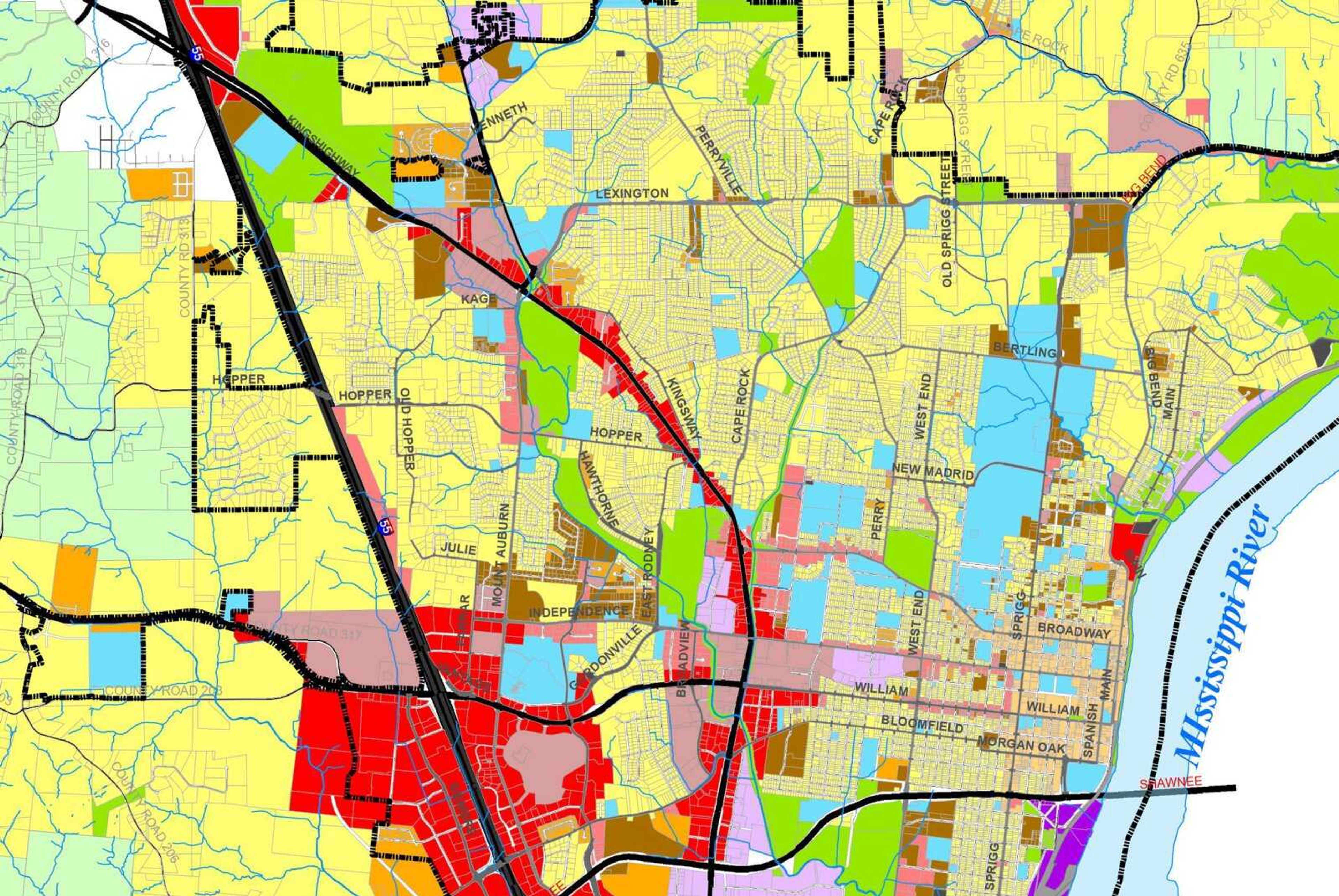
What do decreasing crop yields, an 1854 outbreak of smallpox and missing street signs have in common? They're all problems that could be solved, in part, with geographic information systems (GIS).
GIS has existed since the early 1990s, according to Teresa Heifner, GIS coordinator for the City of Cape Girardeau, and the study and use of GIS and geospatial technology has increased exponentially in the last few decades, especially in Southeast Missouri.
GIS harnesses the power of maps to present data in a useful way.
"I like to call GIS the umbrella that everybody sits under," Heifner said.
Heifner uses GIS to create detailed maps for the City of Cape Girardeau. She uses data to assign characteristics to items on a digital map, such as which parts of the city belong to which ward, police or fire districts.
Cape Girardeau's GIS/Mapping Department has posted several interactive maps on the city's website — www.cityofcapegirardeau.org.
Each map ranges in use — one titled "Gone Girl Driving Tour" plots filming locations the movie's crew visited. Another, the "Public Information Map," provides an array of information about Cape Girardeau.
The map is so detailed, it can display any building's address down to its trash and recycling days.
"It's kind of like an all-inclusive database that has a spatial relationship to it," Heifner said. "It's really the one place where you can go to find out anything and everything you might need to know about the item you're looking for."
Farming
GIS can be used in several capacities, Heifner said.
With just a few strokes on his iPad, Phil Gurley of Nutrien Ag Solutions can tell a grower more about their farm than they could ever know without GIS.
As a precision agricultural manager, Gurley educations Nutrien staff on how to help farmers use GIS to determine where certain parts of fields need to be fertilized and with what type of fertilizer. With satellite images, Gurley can determine crop health by measuring plants' greenness.
Gurley said more farmers use GIS each year — he estimates up to 90% of growers use self-steering tractors to farm land by using GPS.
GIS is the future of farming, even though growers have used it for several years, Gurley said.
"We've been using it, but do we use it to its fullest potential? There are so many different tools in the toolbox," Gurley said.
Receive Daily Headlines FREESign up today!
Education
Efforts have been made locally to educate young students on how to use GIS as a tool.
Last year, the United States Geospatial Intelligence Foundation partnered with the Gateway Global American Youth and Business Alliance in St. Louis. The two entities brought an entry-level geospatial credentialing program to Missouri public schools.
The pilot program began statewide last summer. Students in the program study GIS and geospatial intelligence for 12 weeks. At the end of the program, students ages 16 to 19 may opt to take a test. If they pass, the students earn an entry-level professional certification as a geospatial specialist or technician.
Cape Girardeau Central High School has offered a geospatial specialist course twice, according to Jamie Russell. Russell works as a tech instructional specialist with the Cape Girardeau School District and was instrumental in bringing a geospatial course to the district.
"We teach students how to take data and apply it to the real world, whether it's for a business, farm or factory," Russel said.
Central High School offered the course last summer in a virtual environment. It was also held online last spring through the Air Force Junior Reserve Officer Training Corps. Russel said the school district may offer it again in the spring, but planning and scheduling deliberations are still being made.
During the course, students learn how to use a software called ArcGIS. They utilize the technology to solve practical, real-world problems.
Central's 2021 valedictorian, Emma McDougal, took the course last summer. She said the class discussed how one man, John Snow, used mapping to trace the origin of a smallpox outbreak in London during the 1800s.
McDougal currently studies chemical engineering at the University of Missouri in Columbia, but she finds GIS has a use in almost any field.
"I think the more you learn about maps, the more you realize how location plays into everything," McDougal said. "In terms of engineering, it can be really helpful in determining the best location for a new power plant or processing facility in proximity to different resources or where products need to be delivered."
Some students who have taken the GIS course have used their knowledge to earn internships at local entities, Russel said. One found a full-time paid internship with a local company, and another found a position in the Cape Girardeau County Assessor's Office.
Property
The assessor's office uses mapping to identify areas of real property ownership based on recorded plats, deeds and other methods, according to chief appraiser Tony Smee.
"We then use other layers of data to identify what relevant political subdivisions properties lie in, like fire, school and library districts so entities can set their annual levy rates," Smee said.
When they need updated aerial photos of the county, the assessor's office hires a team to fly planes over the area and take high resolution photos. Thousands of small photos are then stitched together digitally to create a base layer of a map that's on the assessor's website.
The assessor's map is similar to what Heifner creates with Cape Girardeau's GIS department.
Several businesses and government entities rely on the public maps to do their jobs, she said. The city's Public Works Department uses mapping to determine which streets are privately owned so they don't plow them when snow falls. Bicyclists reference a layer Heifner created on the Public Information Map detailing bicycle paths and trails in the city.
"Any career you name to me, I could probably relate it to GIS," Heifner said. "The industry is 20 to 25 years old, but it's growing. Everybody is relying on it now."
Story Tags
Advertisement
Related
Connect with the Southeast Missourian Newsroom:
For corrections to this story or other insights for the editor, click here. To submit a letter to the editor, click here. To learn about the Southeast Missourian’s AI Policy, click here.


Advertisement
Receive Daily Headlines FREESign up today!
