NewsApril 6, 2023
NWS officials recount birth of Glen Allen tornado
Looking at weather-tracking radar images from the early morning hours of Wednesday, April 5, most might see the pixelated reds, yellows and greens as abstract art, but a meteorologist sees a tornado. A tornado touched down around 3:30 a.m. outside Glen Allen, near Marble Hill in Bollinger County, Missouri. National Weather Service officials told The Associated Press the tornado was on the ground for about 20 minutes...
Looking at weather-tracking radar images from the early morning hours of Wednesday, April 5, most might see the pixelated reds, yellows and greens as abstract art, but a meteorologist sees a tornado.
A tornado touched down around 3:30 a.m. outside Glen Allen, near Marble Hill in Bollinger County, Missouri. National Weather Service officials told The Associated Press the tornado was on the ground for about 20 minutes.
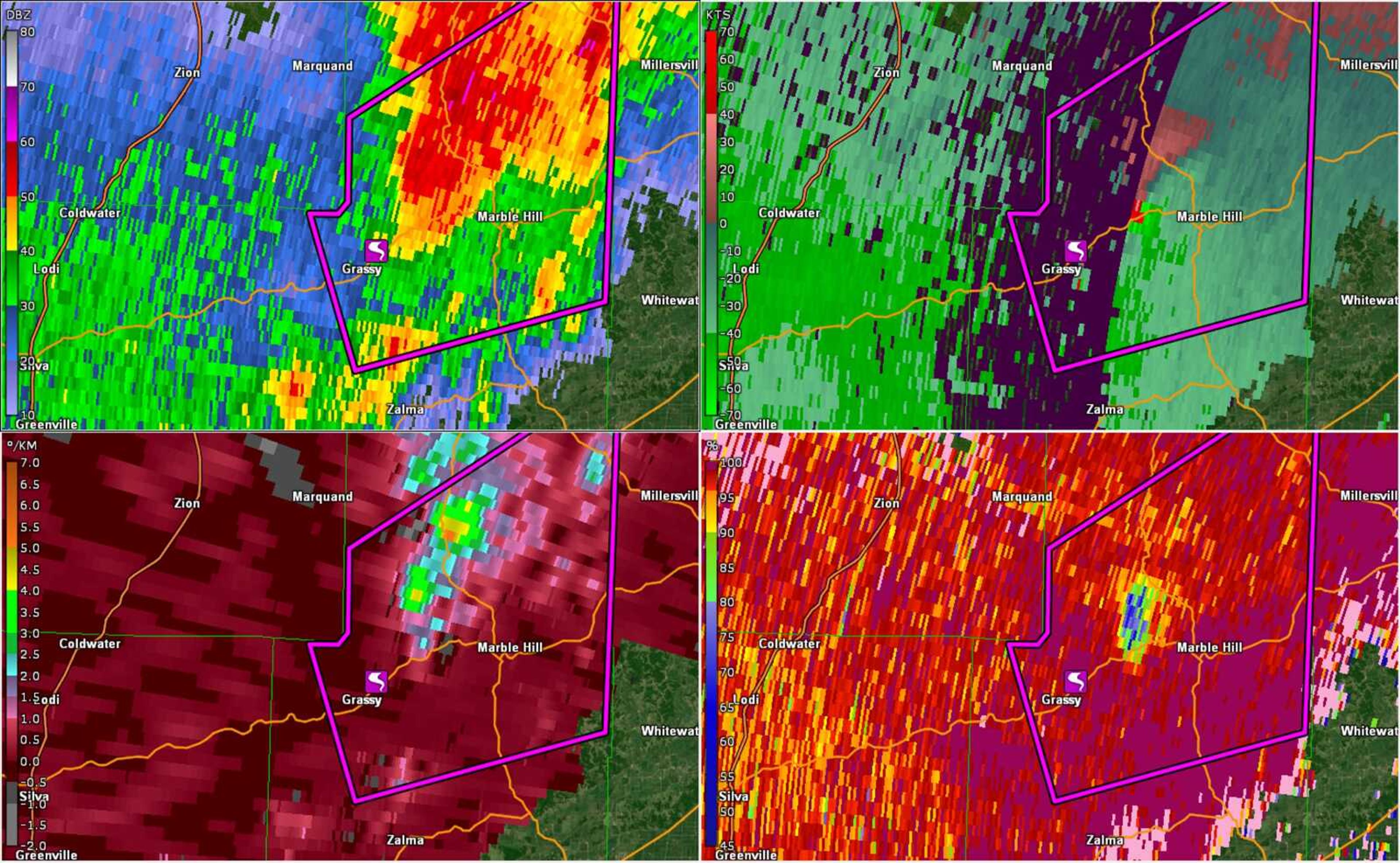
An image provided by David Witten, a meteorologist at the National Weather Service station in Paducah, Kentucky, shows four filtered views of the tornado, time-stamped at 3:42 a.m.
The top right image shows a swath of purple running top to bottom. About halfway down, on the right edge of the purple, is a red plume. According to Witten, that’s the tornado.
He said the applied filter shows relative velocity — or that the weather is showing rotation.
Below that image, on the bottom right, is the Correlation Coefficient filter. Surrounded by splatters of dark red and yellow, there is a splotch of blue, ringed by green. Witten said blue indicates the movement of debris.
Receive Daily Headlines FREESign up today!
When the Paducah NWS team on duty saw these images, they had already sent out tornado warnings to the surrounding areas.
“The good news is we had a lot of lead time on it,” Witten said. “But the problem, because it occurred in the middle of the night, everyone was asleep, so they weren’t able to get the alerts.”
Witten added, even if people were awake, the tornado was “rain wrapped”, and it was dark, so it was doubtful anyone would have been able to see it coming.
Local authorities confirmed five fatalities Wednesday morning.
When Witten or any of the team at the Paducah station see what the radar was showing early Wednesday morning, he said they become “very focused to provide as much lead time as we possibly can.”
“Certainly your heart’s racing if you’re getting an image like that, because you know that this isn’t just some low-end tornado,” Witten said. “This is the real deal that can potentially cause a lot of damage to life and property. And, unfortunately, in this case it did, in the middle of the night.”
Story Tags
Connect with the Southeast Missourian Newsroom:
For corrections to this story or other insights for the editor, click here. To submit a letter to the editor, click here. To learn about the Southeast Missourian’s AI Policy, click here.
Related


Advertisement
Receive Daily Headlines FREESign up today!
