
FeaturesApril 17, 2014
Explore Missouri's 'alphabet soup' back roads
Visitors to Missouri often wonder about the highways that are named with letters instead of numbers. Only one other state (Wisconsin) has a system like it. Missouri's lettered roads lead to plenty of jokes, especially involving the roads named Route PP found in Jackson, Kelso, Poplar Bluff and elsewhere. A game of "Road Sign Scrabble" can be played at certain intersections, such as the junction of Routes N, U and T in Cape Girardeau County...
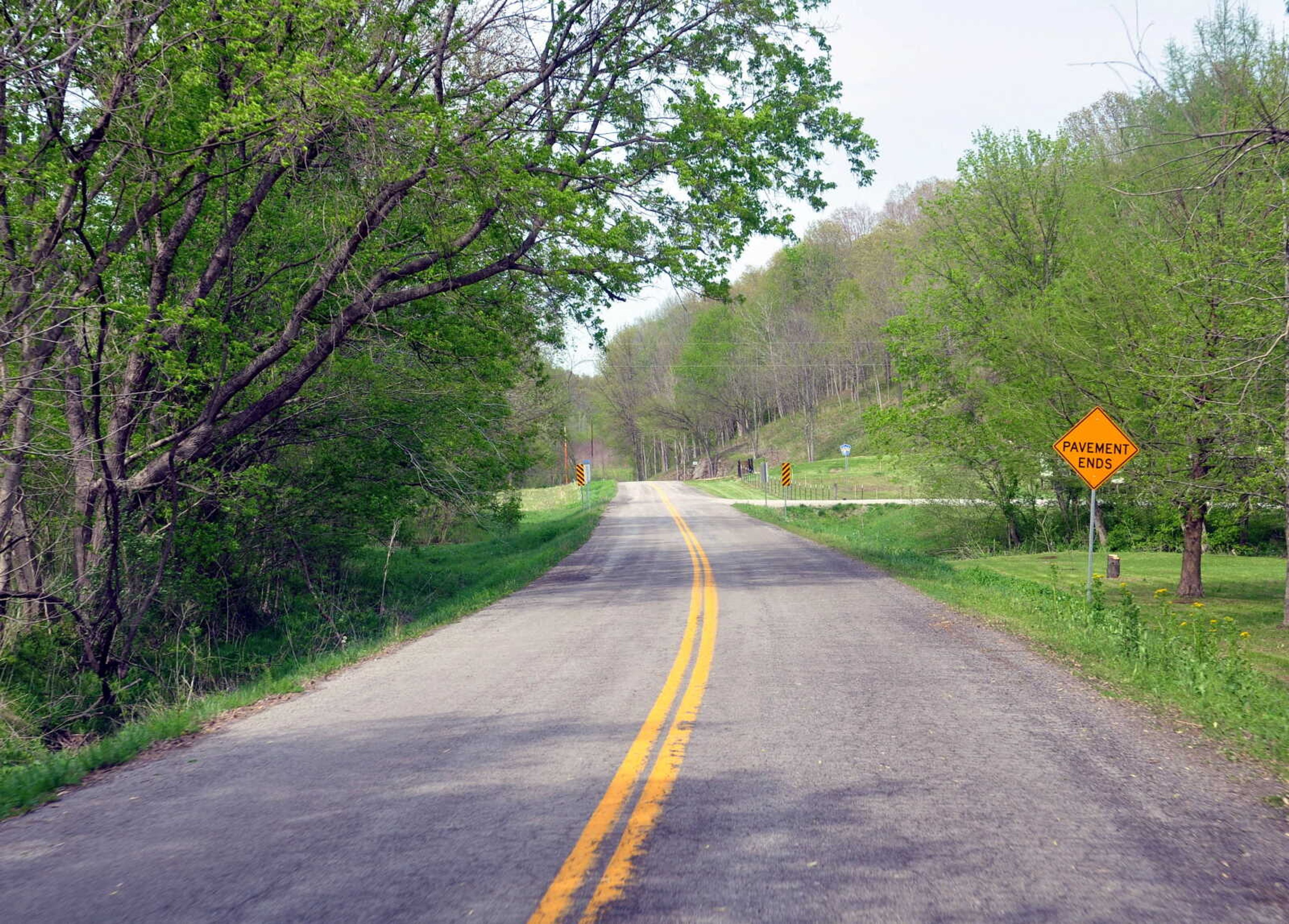
Visitors to Missouri often wonder about the highways that are named with letters instead of numbers. Only one other state (Wisconsin) has a system like it.
Missouri's lettered roads lead to plenty of jokes, especially involving the roads named Route PP found in Jackson, Kelso, Poplar Bluff and elsewhere. A game of "Road Sign Scrabble" can be played at certain intersections, such as the junction of Routes N, U and T in Cape Girardeau County.
There is, however, method to the madness. The first lettered highways started appearing on maps in the 1930s as an effort to provide all-weather roads for farmers living too far from the main numbered highways. Letters were chosen to avoid confusion with the existing highway system.
These farm-to-market roads continued to expand over the decades, boosted in 1952 by the "Takeover Program" in which the state highway department agreed to take over 12,000 miles of former county roads and assign them letters. Missouri had an ambitious goal: bring state roads within two miles of 95 percent of all rural homes, schools, churches, cemeteries and stores.
That goal was surpassed. Even today, many other states don't have that kind of state highway coverage.
One fringe benefit of these "alphabet soup" roads is the large number of scenic byways through the countryside, often with little traffic. Here is a selection of interesting lettered highways in Southeast Missouri.
State Route E (Madison and Iron counties)
This road between Fredericktown and Ironton is postcard-worthy at almost every turn. It passes near three Mark Twain National Forest recreation areas: Marble Creek, Crane Lake and Rock Pile Mountain. In one stretch, the road clings to a narrow ledge between Black Mountain above and St. Francis River below. In wet weather, a spectacular waterfall can be seen immediately next to the road.
State Route D (Madison and Iron counties)
While not as scenic or well-known as Route E, this road also serves as a byway between Fredericktown and Ironton. Curiously, the highway was never completed: it has a gap in the middle connected by a gravel county road. That's just as well, though, since the gap is the most scenic, squeezing between two peaks (Van East Mountain and Blue Mountain) and running alongside a rocky creek (named appropriately Rock Creek). The eastern end of Route D passes Silver Mine Recreation Area as well as the original townsite of Silver Mine, the short-lived boom town that supported the mine.
State Route C (Cape Girardeau and Perry counties)
This road jumps between a series of bucolic towns: Pocahontas, New Wells, Altenburg, Frohna, Brazeau, Farrar and Crosstown. The northernmost portion of Route C passes through the Mississippi River floodplain, dotted by old townsites (such as Belgique and Point Rest) that have succumbed to flooding. The rest of the road traverses a landscape of rolling hills offering sweeping views. With each town spaced a few miles apart, it's not unusual to see a church steeple in the distance from one town to the next. The brick Brazeau Presbyterian Church, built in 1852, is one of the more interesting of these churches.
State Route D (Perry County)
Starting near Longtown and passing through Brazeau, this curvy road eventually ends at the ghost town of Seventy-Six on the Mississippi River. With its enigmatic name, Seventy-Six was once a bustling river landing, but now the area is a state conservation area featuring scenic views of the river.
Receive Daily Headlines FREESign up today!
State Route V (Perry County)
Although short, this road north of Perryville provides excellent views of the sinkholes that are so common throughout Perry County. Sinkholes, of course, are a clue that caves can be found below, and that's certainly true here: Perry County has the most documented caves of any county in Missouri. The area around Route V is home to the longest cave in Missouri, Crevice Cave, with an explored length of around 30 miles, making it the 15th longest known cave in the United States. Although the caves of Perry County aren't open to the general public, Route V does lead to another cave-related landmark that can be visited: Ball Mill Resurgence. At this curious spot, water from the cave system emerges from the base of a massive bluff during wet weather.
State Route J (Madison, Bollinger and Perry counties)
Running northeast from Fredericktown, Route J travels along the upper reaches of both Castor and Whitewater rivers. In Madison County, it passes near the "pink rock" shut-ins of Castor River at Amidon Conservation Area. Route J then enters Bollinger County, but only for a tiny distance between crossing into Perry County. Look for Perry Tower, a fire tower next to the road that can still be climbed -- if you dare.
State Route N (Scott and Mississippi counties)
Connecting Scott City with Charleston, Route N is a study in contrasts: the rolling hills near Scott City versus the flat-as-a-pancake bottoms surrounding Charleston. Zigzagging along the Mississippi River, Route N passes through lands once owned by Sgt. John Ordway of the Lewis and Clark Expedition. After returning from the expedition, Ordway settled in Scott County in 1809, establishing a large plantation with peach and apple orchards. This was all destroyed, however, by the New Madrid earthquakes of 1811-12. Route N also passes the site of Texas Bend, a town settled by German immigrants in the 1840s north of Charleston. The only remnant of the town is a cemetery with a sign in German.
State Route O (Butler County)
It may seem hard to believe, but this narrow, twisty road was once part of U.S. 67, the main highway between Poplar Bluff and St. Louis. Built in 1921, the highway was already a dangerous bottleneck by the early 1930s, requiring construction of a new highway to the west. The old road, now dubbed Route O, has changed little since that time, providing a taste of what early motorists experienced.
State Route U (Ste. Genevieve County)
One of the shortest state roads in Missouri, Route U connects U.S. 61 with Kaskaskia Island, Ill., covering a distance of only 150 yards. The town of St. Mary once stood on the banks of the Mississippi River, but the river's course dramatically shifted to the east in the late 1800s, leaving St. Mary without river access, but still sitting next to the Illinois state line. As the result of this geographic oddity, Route U is the only Missouri state highway that provides direct access to Illinois without crossing the river.
State Route WW (Ste. Genevieve and St. Francois counties)
Starting at the hamlet of Coffman, Route WW passes through the wine country of southern Ste. Genevieve County. A portion of the highway follows "Three Notch Road," the oldest road in Missouri. Dating to the 1700s, the Three Notch Road connected the lead mines at Mine La Motte with the river landing at Ste. Genevieve. This primitive road was so hard to follow that three notches were etched into the trees so that travelers wouldn't get lost. The stretch of Route WW between Holmes Road and Route T closely retraces this historic road.
About James
The webmaster of seMissourian.com and its sister newspapers, James Baughn has lost track of the number of websites he manages. On the side, he maintains even more sites, including Bridgehunter.com, LandmarkHunter.com, TheCapeRock.com and Humorix.
Story Tags
Advertisement
Related
Connect with the Southeast Missourian Newsroom:
For corrections to this story or other insights for the editor, click here. To submit a letter to the editor, click here. To learn about the Southeast Missourian’s AI Policy, click here.
Related


FeaturesOct. 24, 2024


Advertisement
Receive Daily Headlines FREESign up today!
