featuresOctober 16, 2021
Digitized maps highlight Civil War forts -- Fort A
Recently the National Archives has completed digitizing maps prepared by the U.S. Army Corps of Engineers during the Civil War. One of these, a military map of Cape Girardeau, appeared years ago, but now accompanying detailed maps of each of the four forts are available. This column and the succeeding three will focus on the forts...
Recently the National Archives has completed digitizing maps prepared by the U.S. Army Corps of Engineers during the Civil War. One of these, a military map of Cape Girardeau, appeared years ago, but now accompanying detailed maps of each of the four forts are available. This column and the succeeding three will focus on the forts.
Union authorities recognized Cape was a strategic location at the war's beginning, but it lacked a garrison and artillery defense. The first garrison, the 20th Illinois, arrived on July 11, 1861. Within a week, Col. C.C. Marsh directed 2nd Lt. John Wesley Powell to develop a plan of works for the town's defense.
By July 25, Gen. John C. Fremont ordered defenses built in Cape Girardeau and other cities. Fremont dispatched engineer Capt. Franz Kappner to recommend fortifications, and engineer Henry Flad joined them in Cape in early August. Powell submitted his plans to Flad, and construction proceeded. Soldiers in the 20th Illinois and other garrison units, Co. A and Co. C of Bissell's Engineers of the West, local German immigrants and others, and escaped slaves built the forts beginning Aug. 6, starting with Forts A and D. Work finished in October. All were earthen forts, which are more effective than buildings, stone or wooden walls in defense against projectiles.
Fort A began when Col. Marsh fortified "Windmill Hill" on Aug. 4 as an immediate defense of the city. Fortifications occupied the area atop the bluff north of downtown Cape, accessed today via the easternmost block of Bellevue Street, east of Lorimier Street.
Receive Daily Headlines FREESign up today!
Fort A is iconic in Cape's Civil War history because a sketch artist produced a drawing during its construction. The drawing appeared in Frank Leslie's Illustrated Almanac in 1861, and also shows much of the downtown area. The windmill is prominent in the sketch.
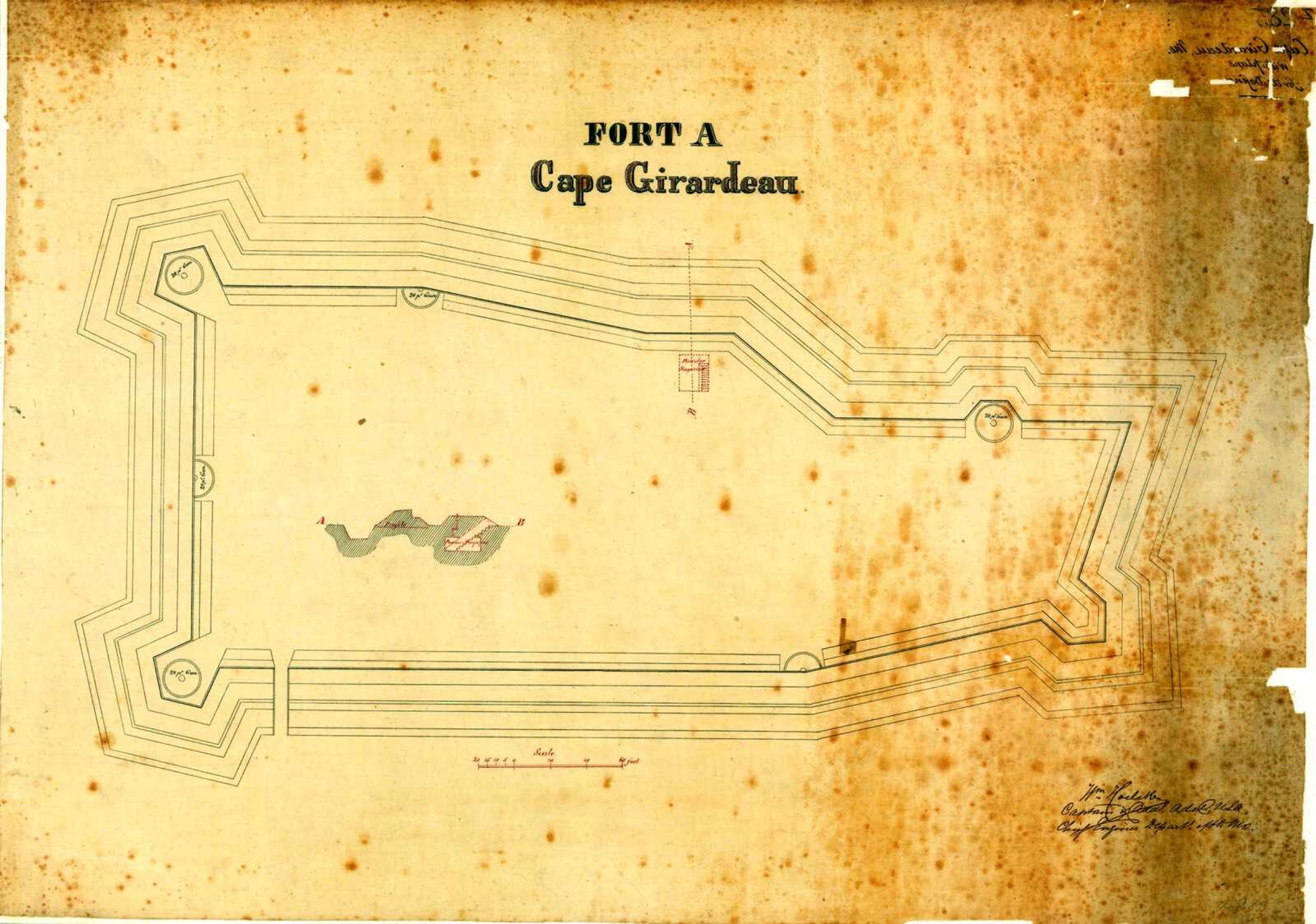
The military map and maps of the forts bear date of September 1865, and illustrate the completed forts. Capt. William Hoelcke of the U.S. Army Corps of Engineers either surveyed or drafted the maps (or both). The map of Fort A does not exactly match the orientation shown on the military map, because the latter shows the orientation as curved to match the lines of the bluff top.
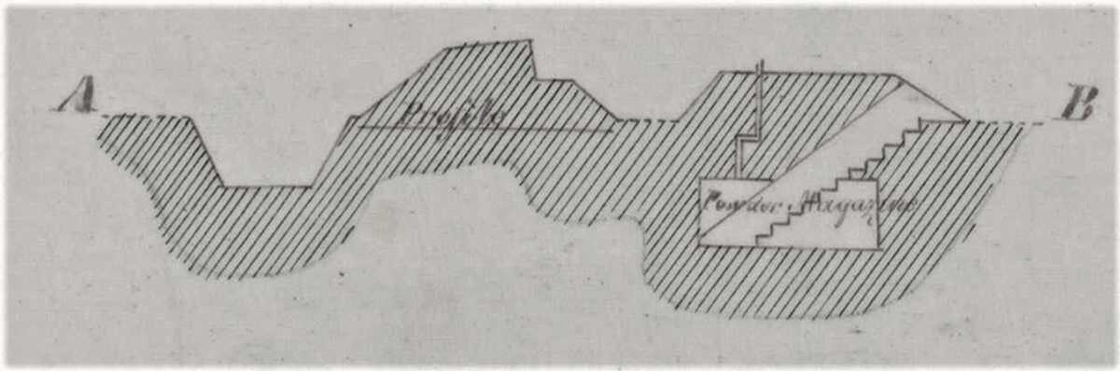
The fort was roughly 650 feet east-west and about 400 feet across at its west end. The map shows placement of five 24-pound cannon, three facing west (toward Lorimier Street) and two north (toward the casino). This is inconsistent with the often-repeated assertion that Fort A partly defended against river attack, which was no threat even at the beginning of the war. Rifle pits show on the military map on the north side of the hill below the walls of the fort, providing additional defense from that direction. The powder magazine, shown in a profile inset on the plat, lay along the north wall. It held ammunition and other supplies, and led roughly 20 feet down steps to a storage chamber with an air shaft.
Story Tags
Connect with the Southeast Missourian Newsroom:
For corrections to this story or other insights for the editor, click here. To submit a letter to the editor, click here. To learn about the Southeast Missourian’s AI Policy, click here.
Related


Advertisement
Receive Daily Headlines FREESign up today!
